Title:
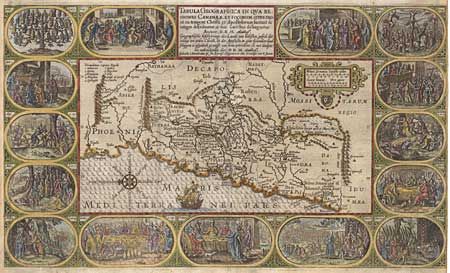
“Tabula Geographica In Qua Regiones Cananaeae, Et Locorum Situs Prout Ea tempore Christi, et Apostolorum suerunt de integro describuntur, ac suis Limitibus distinguntur”
Map Maker:
Johannes Cloppenburg
Graphic map from a Dutch Bible depicting the land ... (full text available to subscribers)
| Item Detail |
| |
| |
MapMaker: |
Johannes Cloppenburg
|
|
| |
| |
Subject: |
Holy Land |
|
| |
Period/Size: |
1640 / 11.5" x 19.5" (29.3 x 49.6 cm)
|
|
| |
Color: |
Colored
|
|
| |
Condition: |
(A) Expert repairs of centerfold, including a couple of tiny lines of facsimile and complete restoration of both side margins with facsimile of about 1/4" of the engraving - all superbly done. (condition help) |
|
| |
Source: |
|
|
| |
References: |
|
|
| |
|
|
| Sales Information |
| |
| |
Price: |
|
|
| |
| |
Offered by: |
Old World Auctions |
|
| |
Catalog: |
Auction No. 97 - Antique Maps, Charts, Atlases & Globes (169) |
|
| |
Lot/Item #: |
399 |
|
| |
| |
Date: |
12/2001
|
|
| |
| |
|
Antique Maps - Valuation and Pricing, Descriptions, Resources |
|
Home |
Information |
Search |
Register |
Contact Us |
Site Map
Americana Exchange, Inc. © 1999 - 2024 Americana Exchange, Inc.. All rights reserved.
OldMaps.com, the OldMaps.com logo and
AMPR are service marks or registered service marks of Americana Exchange, Inc..
|