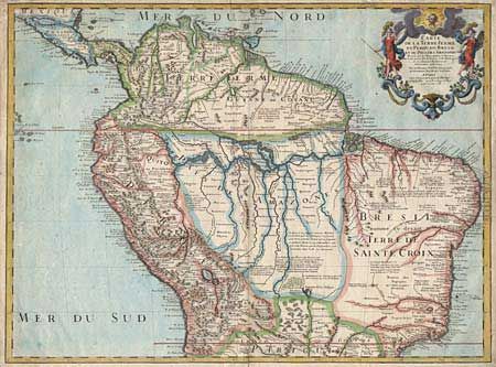
Title:
“Carte de la Terre Ferme du Perou, du Bresil et du Pays des Amazones”
Map Maker:
Guillaume Delisle
Large, graphic map of the northern part of South A... (full text available to subscribers)
| Item Detail |
| |
| |
MapMaker: |
Guillaume Delisle
|
|
| |
| |
Subject: |
Northern South America |
|
| |
Period/Size: |
1703 / 19.0" x 25.5" (48.3 x 64.8 cm)
|
|
| |
Color: |
Colored
|
|
| |
Condition: |
(B) Fully colored by a later hand. Repair of a couple of tears in right border and split on centerfold including a bit of infilled paper with no apparent loss of image. (condition help) |
|
| |
Source: |
|
|
| |
References: |
|
|
| |
|
|
| Sales Information |
| |
| |
Price: |
|
|
| |
| |
Offered by: |
Old World Auctions |
|
| |
Catalog: |
Auction No. 97 - Antique Maps, Charts, Atlases & Globes (169) |
|
| |
Lot/Item #: |
263 |
|
| |
| |
Date: |
12/2001
|
|
| |
| |
|
Antique Maps - Valuation and Pricing, Descriptions, Resources |
|
Home |
Information |
Search |
Register |
Contact Us |
Site Map
Americana Exchange, Inc. © 1999 - 2024 Americana Exchange, Inc.. All rights reserved.
OldMaps.com, the OldMaps.com logo and
AMPR are service marks or registered service marks of Americana Exchange, Inc..
|