Title:
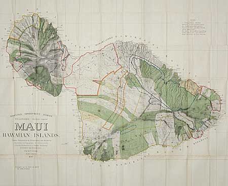
“Maui Hawaiian Islands. Primary Triangulation by W.D. Alexander and S.E. Bishop. Boundaries and Topography by W.D. Alexander, C.J. Lyons, M.D. Monsarrat, F.S. Dodge, S.E. Bishop, E.D. Baldwin, W.R. Lawrence. Map by F.S. Dodge. Scale 1:60000. 1885.”
Map Maker:
Hawaii Territorial Surveys
This is the 1885 edition updated by John M. Donn t... (full text available to subscribers)
| Item Detail |
| |
| |
MapMaker: |
Hawaii Territorial Surveys
|
|
| |
| |
Subject: |
Hawaii |
|
| |
Period/Size: |
1903 / 43.0" x 53.0" (109.3 x 134.7 cm)
|
|
| |
Color: |
Colored
|
|
| |
Condition: |
(B) Great color and strong impression. Toned along some folds with some splits along folds, most repaired on verso with archival tape, else very good. (condition help) |
|
| |
Source: |
|
|
| |
References: |
|
|
| |
|
|
| Sales Information |
| |
| |
Price: |
|
|
| |
| |
Offered by: |
Old World Auctions |
|
| |
Catalog: |
Auction No. 97 - Antique Maps, Charts, Atlases & Globes (169) |
|
| |
Lot/Item #: |
196 |
|
| |
| |
Date: |
12/2001
|
|
| |
| |
|
Antique Maps - Valuation and Pricing, Descriptions, Resources |
|
Home |
Information |
Search |
Register |
Contact Us |
Site Map
Americana Exchange, Inc. © 1999 - 2024 Americana Exchange, Inc.. All rights reserved.
OldMaps.com, the OldMaps.com logo and
AMPR are service marks or registered service marks of Americana Exchange, Inc..
|