Title:
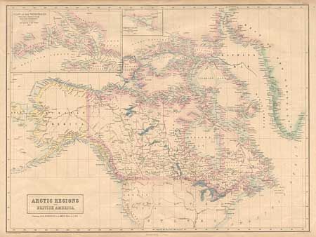
“Arctic Regions and British America. Containing all the Discoveries in the Arctic Seas up to 1853”
Map Maker:
John Bartholomew, Sr.
Detailed map of Canada, Alaska and Greenland with ... (full text available to subscribers)
| Item Detail |
| |
| |
MapMaker: |
John Bartholomew, Sr.
|
|
| |
| |
Subject: |
Canada and Arctic |
|
| |
Period/Size: |
1854 / 16.3" x 21.7" (41.4 x 55.2 cm)
|
|
| |
Color: |
Colored
|
|
| |
Condition: |
(A) Centerfold reinforced with tissue and one insignificant spot. (condition help) |
|
| |
Source: |
Black's General Atlas of the World |
|
| |
References: |
Phillips (A) #4334. |
|
| |
|
|
| Sales Information |
| |
| |
Price: |
|
|
| |
| |
Offered by: |
Old World Auctions |
|
| |
Catalog: |
Auction No. 97 - Antique Maps, Charts, Atlases & Globes (169) |
|
| |
Lot/Item #: |
127 |
|
| |
| |
Date: |
12/2001
|
|
| |
| |
|
Antique Maps - Valuation and Pricing, Descriptions, Resources |
|
Home |
Information |
Search |
Register |
Contact Us |
Site Map
Americana Exchange, Inc. © 1999 - 2024 Americana Exchange, Inc.. All rights reserved.
OldMaps.com, the OldMaps.com logo and
AMPR are service marks or registered service marks of Americana Exchange, Inc..
|