Title:
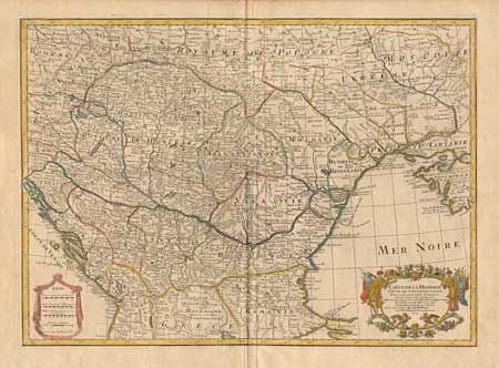
“Carte de la Hongrie et des Pays qui en dependoient autrefois Dress sur un grand nombre de memoires et Cartes manuscrites ou imprimees Rectifiez par les Observations du C.te Marsilii et quelques autres”
Map Maker:
Guillaume Delisle
First state of Delisle's important map of Hungary ... (full text available to subscribers)
| Item Detail |
| |
| |
MapMaker: |
Guillaume Delisle
|
|
| |
| |
Subject: |
Balkans |
|
| |
Period/Size: |
1703 / 18.2" x 25.5" (46.3 x 64.8 cm)
|
|
| |
Color: |
Colored
|
|
| |
Condition: |
(A) Tissue reinforced centerfold, without apparent split. (condition help) |
|
| |
Source: |
Atlas Geographique et Universel |
|
| |
References: |
|
|
| |
|
|
| Sales Information |
| |
| |
Price: |
|
|
| |
| |
Offered by: |
Old World Auctions |
|
| |
Catalog: |
Auction No. 97 - Antique Maps, Charts, Atlases & Globes (169) |
|
| |
Lot/Item #: |
359 |
|
| |
| |
Date: |
12/2001
|
|
| |
| |
|
Antique Maps - Valuation and Pricing, Descriptions, Resources |
|
Home |
Information |
Search |
Register |
Contact Us |
Site Map
Americana Exchange, Inc. © 1999 - 2024 Americana Exchange, Inc.. All rights reserved.
OldMaps.com, the OldMaps.com logo and
AMPR are service marks or registered service marks of Americana Exchange, Inc..
|