Title:
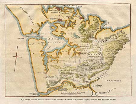
“Map of the Country between Auckland and the River Waikato, New Zealand, Illustrating the War with the Natives”
Map Maker:
Anonymous
An interesting wood engraving of the vicinity invo... (full text available to subscribers)
| Item Detail |
| |
| |
MapMaker: |
Anonymous
|
|
| |
| |
Subject: |
New Zealand |
|
| |
Period/Size: |
1863 / 6.7" x 9.1" (17.1 x 23.2 cm)
|
|
| |
Color: |
Colored
|
|
| |
Condition: |
(A) Trimmed from the newspaper with paper added at top to form a margin for framing. Attractive modern coloring. (condition help) |
|
| |
Source: |
The Illustrated London News |
|
| |
References: |
|
|
| |
|
|
| Sales Information |
| |
| |
Price: |
|
|
| |
| |
Offered by: |
Old World Auctions |
|
| |
Catalog: |
Auction No. 97 - Antique Maps, Charts, Atlases & Globes (169) |
|
| |
Lot/Item #: |
495 |
|
| |
| |
Date: |
12/2001
|
|
| |
| |
|
Antique Maps - Valuation and Pricing, Descriptions, Resources |
|
Home |
Information |
Search |
Register |
Contact Us |
Site Map
Americana Exchange, Inc. © 1999 - 2024 Americana Exchange, Inc.. All rights reserved.
OldMaps.com, the OldMaps.com logo and
AMPR are service marks or registered service marks of Americana Exchange, Inc..
|