Title:
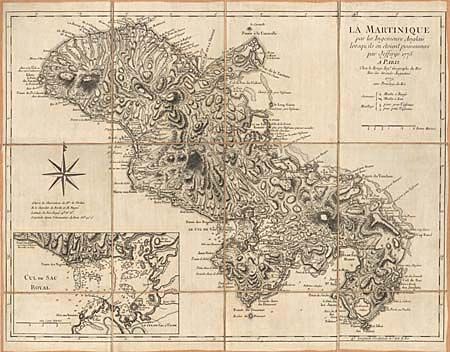
“La Martinique par les Ingenieurs Anglais lorsqu'ils en etoient possesseurs par Jeffreys 1775”
Map Maker:
George Louis Le Rouge
This French version of the 1775 Jeffreys map is sk... (full text available to subscribers)
| Item Detail |
| |
| |
MapMaker: |
George Louis Le Rouge
|
|
| |
| |
Subject: |
Martinique |
|
| |
Period/Size: |
1779 / 18.0" x 24.0" (45.8 x 61.0 cm)
|
|
| |
Color: |
Black & White
|
|
| |
Condition: |
(A) Superb impression and only slight soiling. (condition help) |
|
| |
Source: |
|
|
| |
References: |
|
|
| |
|
|
| Sales Information |
| |
| |
Price: |
|
|
| |
| |
Offered by: |
Old World Auctions |
|
| |
Catalog: |
Auction No. 97 - Antique Maps, Charts, Atlases & Globes (169) |
|
| |
Lot/Item #: |
250 |
|
| |
| |
Date: |
12/2001
|
|
| |
| |
|
Antique Maps - Valuation and Pricing, Descriptions, Resources |
|
Home |
Information |
Search |
Register |
Contact Us |
Site Map
Americana Exchange, Inc. © 1999 - 2024 Americana Exchange, Inc.. All rights reserved.
OldMaps.com, the OldMaps.com logo and
AMPR are service marks or registered service marks of Americana Exchange, Inc..
|