Title:
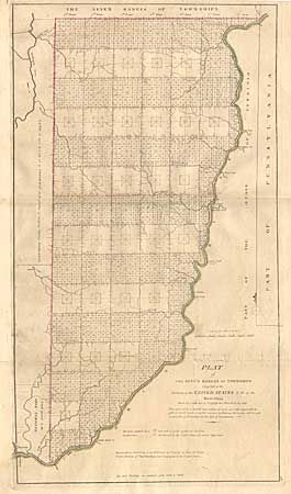
“Plat of the Seven Ranges of Townships being Part of the Territory of the United States N.W. of the River Ohio Which by a late act of Congress are directed to be sold at public auction in Pitsburg…”
Map Maker:
Thomas Hutchins
Copperplate engraving, with original outline hand ... (full text available to subscribers)
| Item Detail |
| |
| |
MapMaker: |
Thomas Hutchins
|
|
| |
| |
Subject: |
Ohio |
|
| |
Period/Size: |
1814 / 24.0" x 13.2" (61.0 x 33.6 cm)
|
|
| |
Color: |
Colored
|
|
| |
Condition: |
(B) Lightly toned with a little offsetting and a small area of surface soiling. (condition help) |
|
| |
Source: |
Mathew Carey's General Atlas |
|
| |
References: |
Phillips (A) 722-28; cf Wheat & Brun 677. |
|
| |
|
|
| Sales Information |
| |
| |
Price: |
|
|
| |
| |
Offered by: |
Old World Auctions |
|
| |
Catalog: |
Auction No. 97 - Antique Maps, Charts, Atlases & Globes (169) |
|
| |
Lot/Item #: |
213 |
|
| |
| |
Date: |
12/2001
|
|
| |
| |
|
Antique Maps - Valuation and Pricing, Descriptions, Resources |
|
Home |
Information |
Search |
Register |
Contact Us |
Site Map
Americana Exchange, Inc. © 1999 - 2024 Americana Exchange, Inc.. All rights reserved.
OldMaps.com, the OldMaps.com logo and
AMPR are service marks or registered service marks of Americana Exchange, Inc..
|