Title:
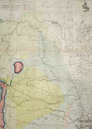
“Map of Nebraska and Dakota, and portions of the States and Territories bordering thereon, compiled by BV'T Maj. Gen. G.K. Warren, Maj. Eng'rs. March 1867.”
Map Maker:
Gouverneur Kemble Warren
A very large and striking map with considerable vi... (full text available to subscribers)
| Item Detail |
| |
| |
MapMaker: |
Gouverneur Kemble Warren
|
|
| |
| |
Subject: |
Nebraska and Dakota |
|
| |
Period/Size: |
1867 / 48.0" x 31.0" (122.0 x 78.8 cm)
|
|
| |
Color: |
Colored
|
|
| |
Condition: |
(A) Close at the left side, as issued. Reinforced with archival tissue and pressed. (condition help) |
|
| |
Source: |
Engineer Department U.S. Army |
|
| |
References: |
|
|
| |
|
|
| Sales Information |
| |
| |
Price: |
|
|
| |
| |
Offered by: |
Old World Auctions |
|
| |
Catalog: |
Auction No. 97 - Antique Maps, Charts, Atlases & Globes (169) |
|
| |
Lot/Item #: |
153 |
|
| |
| |
Date: |
12/2001
|
|
| |
| |
|
Antique Maps - Valuation and Pricing, Descriptions, Resources |
|
Home |
Information |
Search |
Register |
Contact Us |
Site Map
Americana Exchange, Inc. © 1999 - 2024 Americana Exchange, Inc.. All rights reserved.
OldMaps.com, the OldMaps.com logo and
AMPR are service marks or registered service marks of Americana Exchange, Inc..
|