Title:
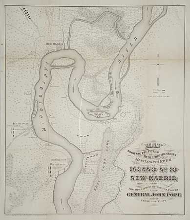
“Map Showing the System of Rebel Fortifications on the Mississippi River at Island No. 10 and New Madrid Also the Operations of the U.S. Forces under General John Pope Against these Positions”
Map Maker:
U.S. War Department
A key map for the CIVIL WAR collector who is int... (full text available to subscribers)
| Item Detail |
| |
| |
MapMaker: |
U.S. War Department
|
|
| |
| |
Subject: |
Missouri and Tennessee |
|
| |
Period/Size: |
1866 / 20.0" x 17.2" (50.8 x 43.7 cm)
|
|
| |
Color: |
Black & White
|
|
| |
Condition: |
(B) Light toning along folds. Backed with archival tissue and pressed. (condition help) |
|
| |
Source: |
Report of Maj. Gen. Pope to the Committee on the Conduct of the War |
|
| |
References: |
Stephenson (CW) #299-8. |
|
| |
|
|
| Sales Information |
| |
| |
Price: |
|
|
| |
| |
Offered by: |
Old World Auctions |
|
| |
Catalog: |
Auction No. 97 - Antique Maps, Charts, Atlases & Globes (169) |
|
| |
Lot/Item #: |
152 |
|
| |
| |
Date: |
12/2001
|
|
| |
| |
|
Antique Maps - Valuation and Pricing, Descriptions, Resources |
|
Home |
Information |
Search |
Register |
Contact Us |
Site Map
Americana Exchange, Inc. © 1999 - 2024 Americana Exchange, Inc.. All rights reserved.
OldMaps.com, the OldMaps.com logo and
AMPR are service marks or registered service marks of Americana Exchange, Inc..
|