Title:
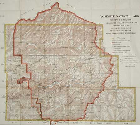
“Yosemite National Park Showing Boundaries Established by Act of Congress approved Feb. 7,1905 and Lands Eliminated therefrom and placed in the Sierra Forest Reservation.”
Map Maker:
General Land Office
A colorful map of the park and area with considera... (full text available to subscribers)
| Item Detail |
| |
| |
MapMaker: |
General Land Office
|
|
| |
| |
Subject: |
California |
|
| |
Period/Size: |
1906 / 24.0" x 27.0" (61.0 x 68.6 cm)
|
|
| |
Color: |
Colored
|
|
| |
Condition: |
(A) Folding, as issued. A couple barely visible offsets. (condition help) |
|
| |
Source: |
HR Doc. 5, 60th Cong., 1st Session |
|
| |
References: |
|
|
| |
|
|
| Sales Information |
| |
| |
Price: |
|
|
| |
| |
Offered by: |
Old World Auctions |
|
| |
Catalog: |
Auction No. 97 - Antique Maps, Charts, Atlases & Globes (169) |
|
| |
Lot/Item #: |
186 |
|
| |
| |
Date: |
12/2001
|
|
| |
| |
|
Antique Maps - Valuation and Pricing, Descriptions, Resources |
|
Home |
Information |
Search |
Register |
Contact Us |
Site Map
Americana Exchange, Inc. © 1999 - 2024 Americana Exchange, Inc.. All rights reserved.
OldMaps.com, the OldMaps.com logo and
AMPR are service marks or registered service marks of Americana Exchange, Inc..
|