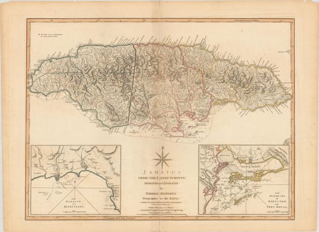
Title:
“Jamaica from the Latest Surveys; Improved and Engraved”
Map Maker:
Jefferys/Laurie & Whittle
This detailed map of Jamaica shows the parishes, t... (full text available to subscribers)
| Item Detail |
| |
| |
MapMaker: |
Jefferys/Laurie & Whittle
|
|
| |
| |
Subject: |
Jamaica |
|
| |
Period/Size: |
1794 / 18.3" x 24.3" (46.5 x 61.8 cm)
|
|
| |
Color: |
Colored
|
|
| |
Condition: |
(B) There is light toning along the centerfold and sheet edges and some minor offsetting. A 4.5" centerfold separation that enters into the map image at bottom has been repaired with hinge tape on verso; the entire centerfold is reinforced with tape. (condition help) |
|
| |
Source: |
|
|
| |
References: |
Kapp (MCC-42) #101. |
|
| |
|
|
| Sales Information |
| |
| |
Price: |
|
|
| |
| |
Offered by: |
Old World Auctions |
|
| |
Catalog: |
Auction No. 179 - Antique Maps, Charts, Atlases & Globes (9525) |
|
| |
Lot/Item #: |
386 |
|
| |
| |
Date: |
09/2020
|
|
| |
| |
|
Antique Maps - Valuation and Pricing, Descriptions, Resources |
|
Home |
Information |
Search |
Register |
Contact Us |
Site Map
Americana Exchange, Inc. © 1999 - 2024 Americana Exchange, Inc.. All rights reserved.
OldMaps.com, the OldMaps.com logo and
AMPR are service marks or registered service marks of Americana Exchange, Inc..
|