Title:
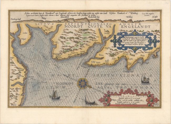
“Beschrijvinghe vande Zee Custen van Engelandt Tusschen Blacqneij en Scharenburch...”
Map Maker:
Lucas Jansz Waghenaer
This uncommon and very early sea chart covers the ... (full text available to subscribers)
| Item Detail |
| |
| |
MapMaker: |
Lucas Jansz Waghenaer
|
|
| |
| |
Subject: |
Eastern England |
|
| |
Period/Size: |
1585 / 12.9" x 20.1" (32.8 x 51.1 cm)
|
|
| |
Color: |
Colored
|
|
| |
Condition: |
(A) A crisp impression on a clean sheet with two tiny wormholes in the image that have been closed on verso with archival materials. (condition help) |
|
| |
Source: |
Spieghel der Zeevaerdt |
|
| |
References: |
Shirley (BL Atlases) M.WAG-1a. |
|
| |
|
|
| Sales Information |
| |
| |
Price: |
|
|
| |
| |
Offered by: |
Old World Auctions |
|
| |
Catalog: |
Auction No. 179 - Antique Maps, Charts, Atlases & Globes (9525) |
|
| |
Lot/Item #: |
472 |
|
| |
| |
Date: |
09/2020
|
|
| |
| |
|
Antique Maps - Valuation and Pricing, Descriptions, Resources |
|
Home |
Information |
Search |
Register |
Contact Us |
Site Map
Americana Exchange, Inc. © 1999 - 2024 Americana Exchange, Inc.. All rights reserved.
OldMaps.com, the OldMaps.com logo and
AMPR are service marks or registered service marks of Americana Exchange, Inc..
|