Title:
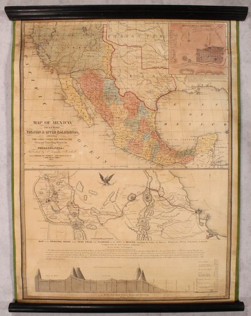
“Map of Mexico, Including Yucatan & Upper California, Exhibiting the Chief Cities and Towns, the Principal Travelling Routes &c.”
Map Maker:
Samuel Augustus Mitchell
This is the second edition of Mitchell's important... (full text available to subscribers)
| Item Detail |
| |
| |
MapMaker: |
Samuel Augustus Mitchell
|
|
| |
| |
Subject: |
Southwestern United States & Mexico |
|
| |
Period/Size: |
1847 / 32.0" x 23.6" (81.3 x 60.0 cm)
|
|
| |
Color: |
Colored
|
|
| |
Condition: |
(B+) An attractive example that has benefited from professional conservation. The map has been backed with new linen to reinforce and repair numerous small cracks and tears mostly at top. There are two small areas of loss below Great Salt Lake that have (condition help) |
|
| |
Source: |
|
|
| |
References: |
Wheat (Gold) #35; Streeter Sale #3869. |
|
| |
|
|
| Sales Information |
| |
| |
Price: |
|
|
| |
| |
Offered by: |
Old World Auctions |
|
| |
Catalog: |
Auction No. 179 - Antique Maps, Charts, Atlases & Globes (9525) |
|
| |
Lot/Item #: |
336 |
|
| |
| |
Date: |
09/2020
|
|
| |
| |
|
Antique Maps - Valuation and Pricing, Descriptions, Resources |
|
Home |
Information |
Search |
Register |
Contact Us |
Site Map
Americana Exchange, Inc. © 1999 - 2024 Americana Exchange, Inc.. All rights reserved.
OldMaps.com, the OldMaps.com logo and
AMPR are service marks or registered service marks of Americana Exchange, Inc..
|