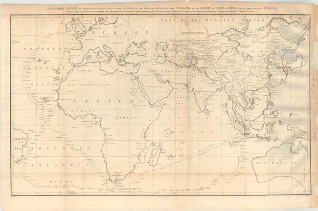
Title:
“A General Chart, on Mercator's Projection, to Shew the Track of the Lion and Hindostan from England to the Gulph of Pekin in China, and of Their Return to England...”
Map Maker:
Sir John Barrow
This large chart was part of an account of George ... (full text available to subscribers)
| Item Detail |
| |
| |
MapMaker: |
Sir John Barrow
|
|
| |
| |
Subject: |
Eastern Hemisphere |
|
| |
Period/Size: |
1796 / 22.4" x 37.0" (56.9 x 94.0 cm)
|
|
| |
Color: |
Black & White
|
|
| |
Condition: |
(B) Issued folding on thick "J Whatman 1794" watermarked paper with minor foxing, a few short fold separations that have been repaired on verso, and some dampstains at top. Several chips in the right blank margin have been replaced with heavy tissue. (condition help) |
|
| |
Source: |
An Authentic Account of an Embassy from the King of Great Britainģ |
|
| |
References: |
Shirley (BL Atlases) G.BARR-1a #1. |
|
| |
|
|
| Sales Information |
| |
| |
Price: |
|
|
| |
| |
Offered by: |
Old World Auctions |
|
| |
Catalog: |
Auction No. 179 - Antique Maps, Charts, Atlases & Globes (9525) |
|
| |
Lot/Item #: |
37 |
|
| |
| |
Date: |
09/2020
|
|
| |
| |
|
Antique Maps - Valuation and Pricing, Descriptions, Resources |
|
Home |
Information |
Search |
Register |
Contact Us |
Site Map
Americana Exchange, Inc. © 1999 - 2024 Americana Exchange, Inc.. All rights reserved.
OldMaps.com, the OldMaps.com logo and
AMPR are service marks or registered service marks of Americana Exchange, Inc..
|