Title:
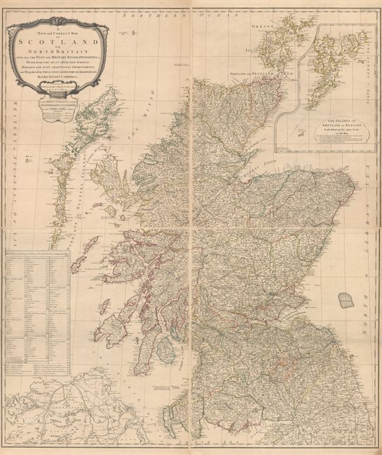
“A New and Correct Map of Scotland or North Britain with All the Post and Military Roads, Divisions &ca…”
Map Maker:
Laurie & Whittle
This handsome and exquisitely detailed four-sheet ... (full text available to subscribers)
| Item Detail |
| |
| |
MapMaker: |
Laurie & Whittle
|
|
| |
| |
Subject: |
Scotland |
|
| |
Period/Size: |
1794 / 24.5" x 20.9" (62.3 x 53.1 cm)
|
|
| |
Color: |
Colored
|
|
| |
Condition: |
(B+) A crisp impression with contemporary outline color. There are minor spots and short edge tears at right and left on each sheet that have been repaired with archival materials on verso. The first image is a composite image - the map is in four separ (condition help) |
|
| |
Source: |
|
|
| |
References: |
Moir, p. 203. |
|
| |
|
|
| Sales Information |
| |
| |
Price: |
|
|
| |
| |
Offered by: |
Old World Auctions |
|
| |
Catalog: |
Auction No. 179 - Antique Maps, Charts, Atlases & Globes (9525) |
|
| |
Lot/Item #: |
491 |
|
| |
| |
Date: |
09/2020
|
|
| |
| |
|
Antique Maps - Valuation and Pricing, Descriptions, Resources |
|
Home |
Information |
Search |
Register |
Contact Us |
Site Map
Americana Exchange, Inc. © 1999 - 2024 Americana Exchange, Inc.. All rights reserved.
OldMaps.com, the OldMaps.com logo and
AMPR are service marks or registered service marks of Americana Exchange, Inc..
|