Title:
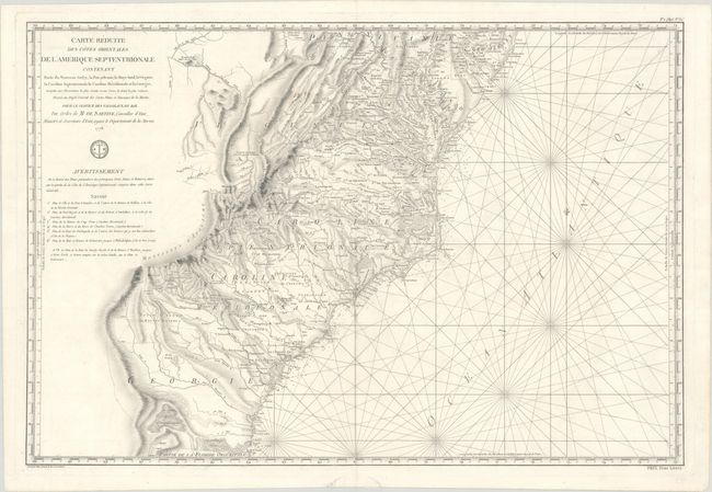
“Carte Reduite des Cotes Orientales de l'Amerique Septentrionale Contenant Partie du Nouveau Jersey, la Pen-sylvanie, le Mary-land, la Virginie, la Caroline Septentrionale, la Caroline Meridionale et la Georgie...”
Map Maker:
Antoine de Sartine
This large, handsome and important Revolutionar... (full text available to subscribers)
| Item Detail |
| |
| |
MapMaker: |
Antoine de Sartine
|
|
| |
| |
Subject: |
Colonial Mid-Atlantic & Southeast United States |
|
| |
Period/Size: |
1778 / 23.1" x 34.3" (58.7 x 87.2 cm)
|
|
| |
Color: |
Black & White
|
|
| |
Condition: |
(A) A nice impression on a bright, sturdy, and watermarked sheet with a few minor spots and a short centerfold separation at bottom that has been closed on verso with archival materials. (condition help) |
|
| |
Source: |
|
|
| |
References: |
|
|
| |
|
|
| Sales Information |
| |
| |
Price: |
|
|
| |
| |
Offered by: |
Old World Auctions |
|
| |
Catalog: |
Auction No. 179 - Antique Maps, Charts, Atlases & Globes (9525) |
|
| |
Lot/Item #: |
177 |
|
| |
| |
Date: |
09/2020
|
|
| |
| |
|
Antique Maps - Valuation and Pricing, Descriptions, Resources |
|
Home |
Information |
Search |
Register |
Contact Us |
Site Map
Americana Exchange, Inc. © 1999 - 2024 Americana Exchange, Inc.. All rights reserved.
OldMaps.com, the OldMaps.com logo and
AMPR are service marks or registered service marks of Americana Exchange, Inc..
|