Title:
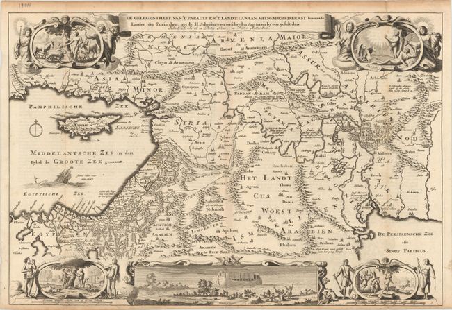
“De Gelegentheyt van 't Paradys en 't Landt Canaan, Mitsgaders d'Eerst Bewoonde Landen der Patriarchen...”
Map Maker:
Daniel Stoopendaal
This Dutch Bible map covers the region between the... (full text available to subscribers)
| Item Detail |
| |
| |
MapMaker: |
Daniel Stoopendaal
|
|
| |
| |
Subject: |
Middle East & Cyprus |
|
| |
Period/Size: |
1710 / 12.1" x 17.8" (30.8 x 45.3 cm)
|
|
| |
Color: |
Black & White
|
|
| |
Condition: |
(B+) Issued folding on watermarked paper with a couple of tiny fold separations at the sheet edges and light toning along the fold lines and top blank margin. (condition help) |
|
| |
Source: |
|
|
| |
References: |
Poortman & Augusteijn #131 GII-2. |
|
| |
|
|
| Sales Information |
| |
| |
Price: |
|
|
| |
| |
Offered by: |
Old World Auctions |
|
| |
Catalog: |
Auction No. 180 - Antique Maps, Charts, Atlases & Globes (9526) |
|
| |
Lot/Item #: |
624 |
|
| |
| |
Date: |
11/2020
|
|
| |
| |
|
Antique Maps - Valuation and Pricing, Descriptions, Resources |
|
Home |
Information |
Search |
Register |
Contact Us |
Site Map
Americana Exchange, Inc. © 1999 - 2024 Americana Exchange, Inc.. All rights reserved.
OldMaps.com, the OldMaps.com logo and
AMPR are service marks or registered service marks of Americana Exchange, Inc..
|