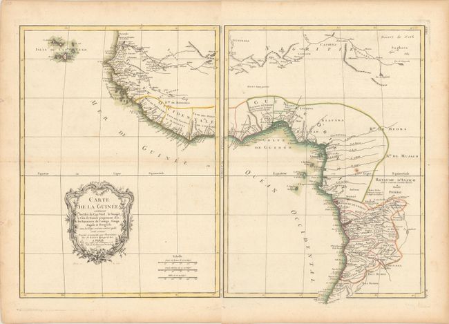
Title:
“Carte de la Guinee Contenant les Isles du Cap Verd, le Senegal, la Cote de Guinee Proprement Dite, les Royaumes de Loango, Congo, Angola et Benguela…”
Map Maker:
Bonne/Lattre
This attractive map of Western Africa provides a d... (full text available to subscribers)
| Item Detail |
| |
| |
MapMaker: |
Bonne/Lattre
|
|
| |
| |
Subject: |
Western Africa |
|
| |
Period/Size: |
1771 / 16.7" x 12.3" (42.5 x 31.3 cm)
|
|
| |
Color: |
Colored
|
|
| |
Condition: |
(B+) Nice impressions on watermarked paper with minor scattered foxing. The eastern sheet has two tiny holes only visible when held to light. The first image is a composite image - the map is in two separate sheets. (condition help) |
|
| |
Source: |
|
|
| |
References: |
|
|
| |
|
|
| Sales Information |
| |
| |
Price: |
|
|
| |
| |
Offered by: |
Old World Auctions |
|
| |
Catalog: |
Auction No. 180 - Antique Maps, Charts, Atlases & Globes (9526) |
|
| |
Lot/Item #: |
737 |
|
| |
| |
Date: |
11/2020
|
|
| |
| |
|
Antique Maps - Valuation and Pricing, Descriptions, Resources |
|
Home |
Information |
Search |
Register |
Contact Us |
Site Map
Americana Exchange, Inc. © 1999 - 2024 Americana Exchange, Inc.. All rights reserved.
OldMaps.com, the OldMaps.com logo and
AMPR are service marks or registered service marks of Americana Exchange, Inc..
|