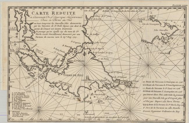
Title:
“Carte Reduite de l'Extremite de l'Amerique Meridionale dans la Partie du Sud...”
Map Maker:
Amedee Francois Frezier
This rare, small French map shows the recent disco... (full text available to subscribers)
| Item Detail |
| |
| |
MapMaker: |
Amedee Francois Frezier
|
|
| |
| |
Subject: |
Strait of Magellan |
|
| |
Period/Size: |
1717 / 7.4" x 11.4" (18.8 x 29.0 cm)
|
|
| |
Color: |
Black & White
|
|
| |
Condition: |
(A) A crisp impression on a bright sheet, issued folding with a small paper flaw at bottom center. There is a binding trim at left and bottom that extends to the neatline. (condition help) |
|
| |
Source: |
Relation du Voyage de la Mer du Sud aux Cotes du Chili et du Perou |
|
| |
References: |
Shirley (BL Atlases) G.FREZ-2a #20. |
|
| |
|
|
| Sales Information |
| |
| |
Price: |
|
|
| |
| |
Offered by: |
Old World Auctions |
|
| |
Catalog: |
Auction No. 180 - Antique Maps, Charts, Atlases & Globes (9526) |
|
| |
Lot/Item #: |
384 |
|
| |
| |
Date: |
11/2020
|
|
| |
| |
|
Antique Maps - Valuation and Pricing, Descriptions, Resources |
|
Home |
Information |
Search |
Register |
Contact Us |
Site Map
Americana Exchange, Inc. © 1999 - 2024 Americana Exchange, Inc.. All rights reserved.
OldMaps.com, the OldMaps.com logo and
AMPR are service marks or registered service marks of Americana Exchange, Inc..
|