Title:
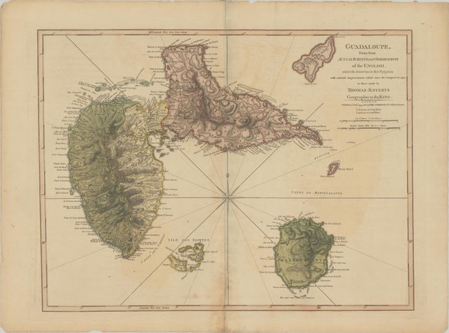
“Guadaloupe, Done from Actual Surveys and Observations of the English, Whilst the Island Was in Their Possession with Material Improvements Added Since the Conquest in 1794...”
Map Maker:
Jefferys/Laurie & Whittle
A sharply engraved map with tremendous coastal det... (full text available to subscribers)
| Item Detail |
| |
| |
MapMaker: |
Jefferys/Laurie & Whittle
|
|
| |
| |
Subject: |
Guadeloupe |
|
| |
Period/Size: |
1795 / 18.1" x 24.0" (46.0 x 61.0 cm)
|
|
| |
Color: |
Colored
|
|
| |
Condition: |
(B) A nice impression on paper with the watermarks of a large fleur-de-lis coat of arms and the initials "RG." There is light offsetting and toning and centerfold separations at top and bottom that have been closed on verso with tape. An edge tear at bo (condition help) |
|
| |
Source: |
The West-India Islands |
|
| |
References: |
cf. Shirley (BL Atlases) M.JEF-4a #29. |
|
| |
|
|
| Sales Information |
| |
| |
Price: |
|
|
| |
| |
Offered by: |
Old World Auctions |
|
| |
Catalog: |
Auction No. 180 - Antique Maps, Charts, Atlases & Globes (9526) |
|
| |
Lot/Item #: |
350 |
|
| |
| |
Date: |
11/2020
|
|
| |
| |
|
Antique Maps - Valuation and Pricing, Descriptions, Resources |
|
Home |
Information |
Search |
Register |
Contact Us |
Site Map
Americana Exchange, Inc. © 1999 - 2024 Americana Exchange, Inc.. All rights reserved.
OldMaps.com, the OldMaps.com logo and
AMPR are service marks or registered service marks of Americana Exchange, Inc..
|