Title:
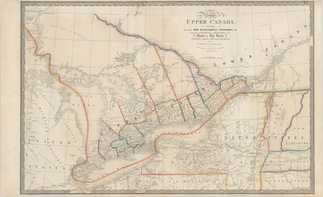
“A Map of the Province of Upper Canada, Describing All the New Settlements, Townships, &c. with the Countries Adjacent, from Quebec to Lake Huron...”
Map Maker:
James Wyld
A large and boldly engraved copper plate map. It ... (full text available to subscribers)
| Item Detail |
| |
| |
MapMaker: |
James Wyld
|
|
| |
| |
Subject: |
Eastern United States & Canada |
|
| |
Period/Size: |
1850 / 22.5" x 34.3" (57.2 x 87.2 cm)
|
|
| |
Color: |
Colored
|
|
| |
Condition: |
(B+) A crisp impression with contemporary outline color on a sturdy sheet, issued folding with light soiling, faint offsetting, and a few tiny abrasions along the left-hand fold at bottom. There are archival repairs to several minor separations along the (condition help) |
|
| |
Source: |
|
|
| |
References: |
Tooley (Amer) p.102 #82g. |
|
| |
|
|
| Sales Information |
| |
| |
Price: |
|
|
| |
| |
Offered by: |
Old World Auctions |
|
| |
Catalog: |
Auction No. 180 - Antique Maps, Charts, Atlases & Globes (9526) |
|
| |
Lot/Item #: |
110 |
|
| |
| |
Date: |
11/2020
|
|
| |
| |
|
Antique Maps - Valuation and Pricing, Descriptions, Resources |
|
Home |
Information |
Search |
Register |
Contact Us |
Site Map
Americana Exchange, Inc. © 1999 - 2024 Americana Exchange, Inc.. All rights reserved.
OldMaps.com, the OldMaps.com logo and
AMPR are service marks or registered service marks of Americana Exchange, Inc..
|