Title:
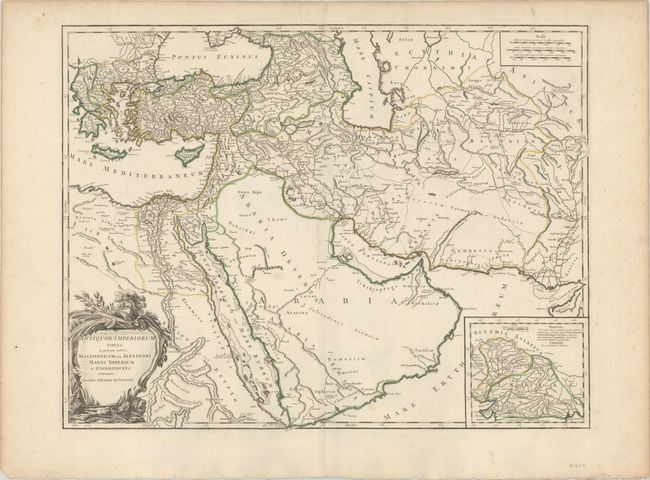
“Antiquor? Imperiorum Tabula, in qua Prae Caeteris Macedonicum seu Alexandri Magni Imperium et Expeditiones Exarantur”
Map Maker:
Didier Robert de Vaugondy
This is the second state of this large map of the ... (full text available to subscribers)
| Item Detail |
| |
| |
MapMaker: |
Didier Robert de Vaugondy
|
|
| |
| |
Subject: |
Middle East |
|
| |
Period/Size: |
1768 / 18.7" x 24.3" (47.5 x 61.8 cm)
|
|
| |
Color: |
Colored
|
|
| |
Condition: |
(A) A nice impression with contemporary outline color on a bright sheet with a small chapel watermark. There is marginal soiling and light toning along the edges of the sheet. (condition help) |
|
| |
Source: |
Atlas Universel |
|
| |
References: |
Pedley #382. |
|
| |
|
|
| Sales Information |
| |
| |
Price: |
|
|
| |
| |
Offered by: |
Old World Auctions |
|
| |
Catalog: |
Auction No. 180 - Antique Maps, Charts, Atlases & Globes (9526) |
|
| |
Lot/Item #: |
618 |
|
| |
| |
Date: |
11/2020
|
|
| |
| |
|
Antique Maps - Valuation and Pricing, Descriptions, Resources |
|
Home |
Information |
Search |
Register |
Contact Us |
Site Map
Americana Exchange, Inc. © 1999 - 2024 Americana Exchange, Inc.. All rights reserved.
OldMaps.com, the OldMaps.com logo and
AMPR are service marks or registered service marks of Americana Exchange, Inc..
|