Title:
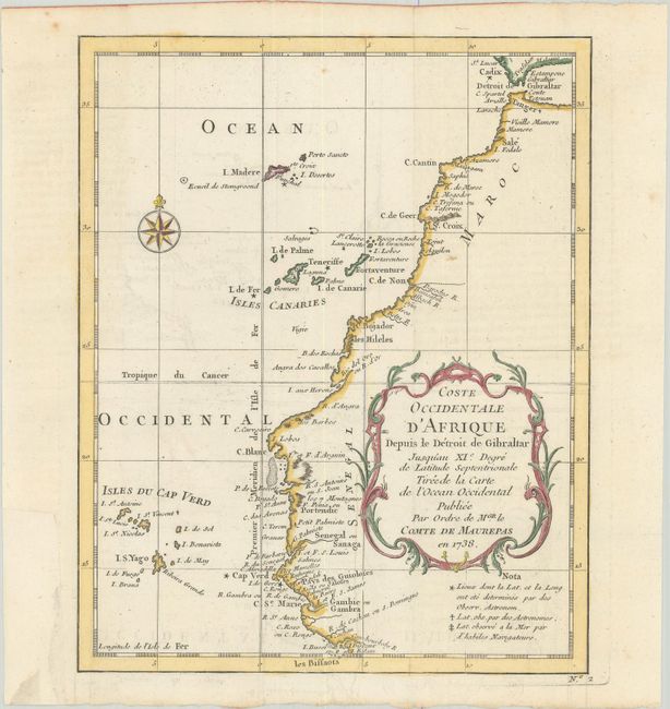
“Coste Occidentale d'Afrique Depuis le Detroit de Gibraltar Jusqu'au XIe Degre de Latitude Septentrionale Tiree de la Carte de l'Ocean Occidental”
Map Maker:
Jacques Nicolas Bellin
Map of the northwestern coast of Africa covering f... (full text available to subscribers)
| Item Detail |
| |
| |
MapMaker: |
Jacques Nicolas Bellin
|
|
| |
| |
Subject: |
Northwestern Africa |
|
| |
Period/Size: |
1738 / 9.7" x 7.8" (24.7 x 19.9 cm)
|
|
| |
Color: |
Colored
|
|
| |
Condition: |
(A) Issued folding on a bright sheet with faint offsetting and a binding trim at bottom left that has been professionally replaced with period-correct paper. (condition help) |
|
| |
Source: |
|
|
| |
References: |
|
|
| |
|
|
| Sales Information |
| |
| |
Price: |
|
|
| |
| |
Offered by: |
Old World Auctions |
|
| |
Catalog: |
Auction No. 180 - Antique Maps, Charts, Atlases & Globes (9526) |
|
| |
Lot/Item #: |
722 |
|
| |
| |
Date: |
11/2020
|
|
| |
| |
|
Antique Maps - Valuation and Pricing, Descriptions, Resources |
|
Home |
Information |
Search |
Register |
Contact Us |
Site Map
Americana Exchange, Inc. © 1999 - 2024 Americana Exchange, Inc.. All rights reserved.
OldMaps.com, the OldMaps.com logo and
AMPR are service marks or registered service marks of Americana Exchange, Inc..
|