Title:
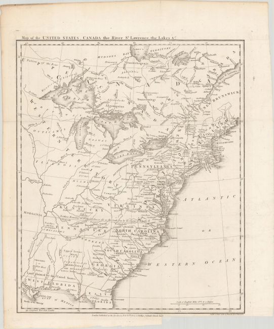
“Map of the United States, Canada the River St. Lawrence, the Lakes &c.”
Map Maker:
Richard Phillips
This great map of the fledgling nation includes nu... (full text available to subscribers)
| Item Detail |
| |
| |
MapMaker: |
Richard Phillips
|
|
| |
| |
Subject: |
Eastern United States & Canada, Franklin |
|
| |
Period/Size: |
1801 / 16.0" x 13.4" (40.7 x 34.1 cm)
|
|
| |
Color: |
Black & White
|
|
| |
Condition: |
(A) Issued folding on a bright sheet with a binding trim in the bottom margin and a short associated binding tear that has been closed with archival materials on verso. (condition help) |
|
| |
Source: |
British Military Library, or Journal |
|
| |
References: |
Dotson & Baker (OWA) #14a.1; Baynton-Williams #11i. |
|
| |
|
|
| Sales Information |
| |
| |
Price: |
|
|
| |
| |
Offered by: |
Old World Auctions |
|
| |
Catalog: |
Auction No. 180 - Antique Maps, Charts, Atlases & Globes (9526) |
|
| |
Lot/Item #: |
109 |
|
| |
| |
Date: |
11/2020
|
|
| |
| |
|
Antique Maps - Valuation and Pricing, Descriptions, Resources |
|
Home |
Information |
Search |
Register |
Contact Us |
Site Map
Americana Exchange, Inc. © 1999 - 2024 Americana Exchange, Inc.. All rights reserved.
OldMaps.com, the OldMaps.com logo and
AMPR are service marks or registered service marks of Americana Exchange, Inc..
|