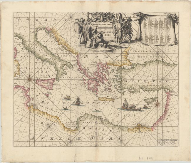
Title:
“Orientalior Districtus Maris Mediterranei / T' Ooster Gedeelte van de Middelandse Zee”
Map Maker:
Reiner and Joshua Ottens
An attractive chart of the eastern Mediterranean, ... (full text available to subscribers)
| Item Detail |
| |
| |
MapMaker: |
Reiner and Joshua Ottens
|
|
| |
| |
Subject: |
Eastern Mediterranean |
|
| |
Period/Size: |
1739 / 18.5" x 22.6" (47.0 x 57.4 cm)
|
|
| |
Color: |
Colored
|
|
| |
Condition: |
(A) A crisp impression with some minor staining along the lower centerfold. There are some light dampstains along the sheet edges, far from the map image. (condition help) |
|
| |
Source: |
|
|
| |
References: |
|
|
| |
|
|
| Sales Information |
| |
| |
Price: |
|
|
| |
| |
Offered by: |
Old World Auctions |
|
| |
Catalog: |
Auction No. 180 - Antique Maps, Charts, Atlases & Globes (9526) |
|
| |
Lot/Item #: |
609 |
|
| |
| |
Date: |
11/2020
|
|
| |
| |
|
Antique Maps - Valuation and Pricing, Descriptions, Resources |
|
Home |
Information |
Search |
Register |
Contact Us |
Site Map
Americana Exchange, Inc. © 1999 - 2024 Americana Exchange, Inc.. All rights reserved.
OldMaps.com, the OldMaps.com logo and
AMPR are service marks or registered service marks of Americana Exchange, Inc..
|