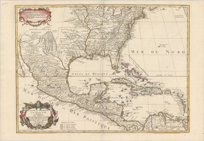
Title:
“Carte du Mexique et des Etats Unis d'Amerique, Partie Meridionale. Dressee sur un Grand Nombre de Memoires...”
Map Maker:
Delisle/Dezauche
The title of this map contains a very early recogn... (full text available to subscribers)
| Item Detail |
| |
| |
MapMaker: |
Delisle/Dezauche
|
|
| |
| |
Subject: |
Colonial Eastern North America & West Indies |
|
| |
Period/Size: |
1783 / 18.9" x 25.5" (48.0 x 64.8 cm)
|
|
| |
Color: |
Colored
|
|
| |
Condition: |
(A) A crisp impression on a watermarked sheet. (condition help) |
|
| |
Source: |
|
|
| |
References: |
Tooley (Amer) p.22 #53; cf. Cumming (SE) #137; Martin (TX) p.92-3. |
|
| |
|
|
| Sales Information |
| |
| |
Price: |
|
|
| |
| |
Offered by: |
Old World Auctions |
|
| |
Catalog: |
Auction No. 180 - Antique Maps, Charts, Atlases & Globes (9526) |
|
| |
Lot/Item #: |
91 |
|
| |
| |
Date: |
11/2020
|
|
| |
| |
|
Antique Maps - Valuation and Pricing, Descriptions, Resources |
|
Home |
Information |
Search |
Register |
Contact Us |
Site Map
Americana Exchange, Inc. © 1999 - 2024 Americana Exchange, Inc.. All rights reserved.
OldMaps.com, the OldMaps.com logo and
AMPR are service marks or registered service marks of Americana Exchange, Inc..
|