Title:
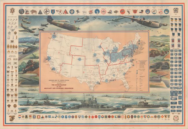
“Defense Map of United States Prepared by C.S. Hammond & Co. N.Y. Showing the Mobilization of Our Military and Economic Resources”
Map Maker:
C.S. Hammond [& Co.]
Prior to World War II, pictorial maps portrayed mi... (full text available to subscribers)
| Item Detail |
| |
| |
MapMaker: |
C.S. Hammond [& Co.]
|
|
| |
| |
Subject: |
United States, World War II |
|
| |
Period/Size: |
1941 / 21.1" x 31.0" (53.6 x 78.8 cm)
|
|
| |
Color: |
Colored
|
|
| |
Condition: |
(B+) Issued folding on a clean sheet with additional folds created by a previous owner. There are several tiny splits at the fold junctions and a 1.5" edge tear that just enters the border at bottom that has been closed on verso with archival tape. (condition help) |
|
| |
Source: |
|
|
| |
References: |
Hornsby (Picturing America) pp. 225, 230-31. |
|
| |
|
|
| Sales Information |
| |
| |
Price: |
|
|
| |
| |
Offered by: |
Old World Auctions |
|
| |
Catalog: |
Auction No. 180 - Antique Maps, Charts, Atlases & Globes (9526) |
|
| |
Lot/Item #: |
134 |
|
| |
| |
Date: |
11/2020
|
|
| |
| |
|
Antique Maps - Valuation and Pricing, Descriptions, Resources |
|
Home |
Information |
Search |
Register |
Contact Us |
Site Map
Americana Exchange, Inc. © 1999 - 2024 Americana Exchange, Inc.. All rights reserved.
OldMaps.com, the OldMaps.com logo and
AMPR are service marks or registered service marks of Americana Exchange, Inc..
|