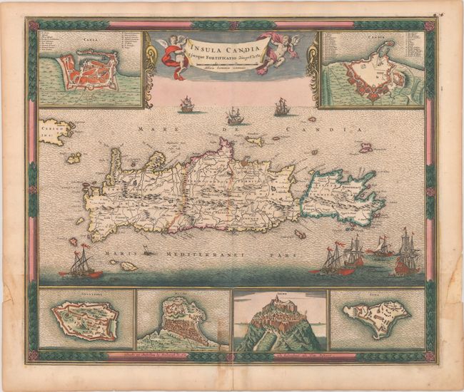
Title:
“Insula Candia Ejusque Fortificatio”
Map Maker:
Frederick de Wit
This dramatic map of Crete shows the island follow... (full text available to subscribers)
| Item Detail |
| |
| |
MapMaker: |
Frederick de Wit
|
|
| |
| |
Subject: |
Crete |
|
| |
Period/Size: |
1688 / 18.1" x 21.5" (46.0 x 54.7 cm)
|
|
| |
Color: |
Colored
|
|
| |
Condition: |
(B+) A strong impression with light scattered foxing. There is a 2.5" fold separation at bottom that has been closed on verso with old paper with some minor staining visible due to the adhesive used in the repair. Two small chips in the side margins hav (condition help) |
|
| |
Source: |
|
|
| |
References: |
Zacharakis #2392. |
|
| |
|
|
| Sales Information |
| |
| |
Price: |
|
|
| |
| |
Offered by: |
Old World Auctions |
|
| |
Catalog: |
Auction No. 181 - Antique Maps, Charts, Atlases & Globes (9527) |
|
| |
Lot/Item #: |
564 |
|
| |
| |
Date: |
02/2021
|
|
| |
| |
|
Antique Maps - Valuation and Pricing, Descriptions, Resources |
|
Home |
Information |
Search |
Register |
Contact Us |
Site Map
Americana Exchange, Inc. © 1999 - 2024 Americana Exchange, Inc.. All rights reserved.
OldMaps.com, the OldMaps.com logo and
AMPR are service marks or registered service marks of Americana Exchange, Inc..
|