Title:
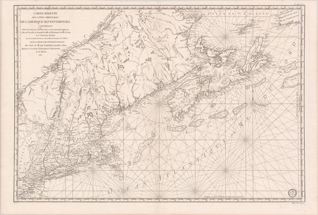
“Carte Reduite des Cotes Orientales de l'Amerique Septentrionale. Contenant Celles des Provinces de New-York et de la Nouvelle Angleterre, Celle de l'Acadie ou Nouvelle Ecosse...”
Map Maker:
Antoine de Sartine
This fine chart was prepared under the direction o... (full text available to subscribers)
| Item Detail |
| |
| |
MapMaker: |
Antoine de Sartine
|
|
| |
| |
Subject: |
Colonial Northeastern United States & Canada |
|
| |
Period/Size: |
1780 / 23.1" x 34.3" (58.7 x 87.2 cm)
|
|
| |
Color: |
Black & White
|
|
| |
Condition: |
(A) A crisp impression on a clean bright sheet with a couple of minor stains at top right and left. (condition help) |
|
| |
Source: |
Neptune Americo-Septentrional |
|
| |
References: |
McCorkle #780.3; Kershaw #754; Sellers & Van Ee #216. |
|
| |
|
|
| Sales Information |
| |
| |
Price: |
|
|
| |
| |
Offered by: |
Old World Auctions |
|
| |
Catalog: |
Auction No. 181 - Antique Maps, Charts, Atlases & Globes (9527) |
|
| |
Lot/Item #: |
117 |
|
| |
| |
Date: |
02/2021
|
|
| |
| |
|
Antique Maps - Valuation and Pricing, Descriptions, Resources |
|
Home |
Information |
Search |
Register |
Contact Us |
Site Map
Americana Exchange, Inc. © 1999 - 2024 Americana Exchange, Inc.. All rights reserved.
OldMaps.com, the OldMaps.com logo and
AMPR are service marks or registered service marks of Americana Exchange, Inc..
|