Title:
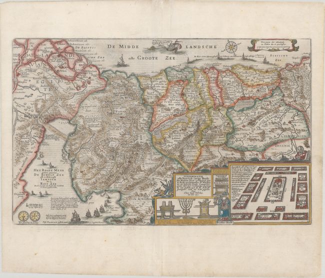
“Perigrinatie ofte Veertich-Iarige Reyse, der Kinderen Israels uyt Egipten, door de Rood-Zee; Mitsgaders de Woestyne tot int Beloofde Landt Canaan...”
Map Maker:
Claes Jansz[oon] Visscher
Lavishly decorated map of the Holy Land depicting ... (full text available to subscribers)
| Item Detail |
| |
| |
MapMaker: |
Claes Jansz[oon] Visscher
|
|
| |
| |
Subject: |
Holy Land |
|
| |
Period/Size: |
1650 / 11.9" x 19.1" (30.3 x 48.6 cm)
|
|
| |
Color: |
Colored
|
|
| |
Condition: |
(A) A bright sheet with professional repairs to a centerfold separation that enters about 1" into image at bottom and a few very short edge tears at top. (condition help) |
|
| |
Source: |
|
|
| |
References: |
Laor #785; Poortman & Augusteijn #85. |
|
| |
|
|
| Sales Information |
| |
| |
Price: |
|
|
| |
| |
Offered by: |
Old World Auctions |
|
| |
Catalog: |
Auction No. 181 - Antique Maps, Charts, Atlases & Globes (9527) |
|
| |
Lot/Item #: |
590 |
|
| |
| |
Date: |
02/2021
|
|
| |
| |
|
Antique Maps - Valuation and Pricing, Descriptions, Resources |
|
Home |
Information |
Search |
Register |
Contact Us |
Site Map
Americana Exchange, Inc. © 1999 - 2024 Americana Exchange, Inc.. All rights reserved.
OldMaps.com, the OldMaps.com logo and
AMPR are service marks or registered service marks of Americana Exchange, Inc..
|