Title:
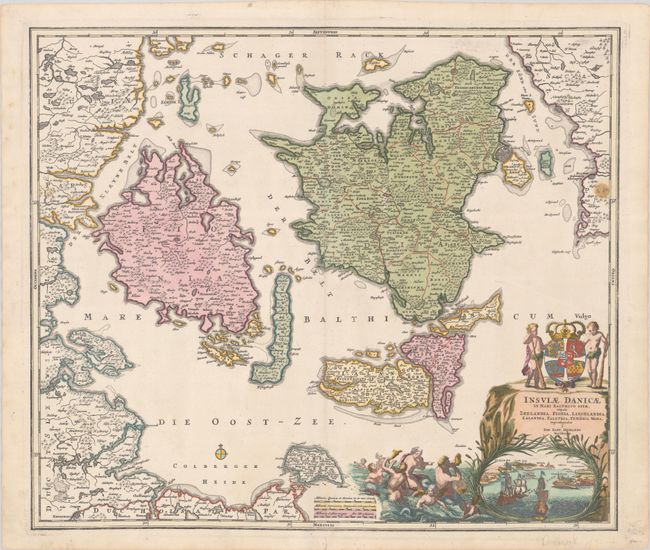
“Insulae Danicae in Mari Balthico Sitae, Utpote Zeelandia, Fionia, Langelandia, Lalandia, Falstria, Fembria Mona, Repraesentatae”
Map Maker:
Johann Baptist Homann
This very detailed and finely engraved chart shows... (full text available to subscribers)
| Item Detail |
| |
| |
MapMaker: |
Johann Baptist Homann
|
|
| |
| |
Subject: |
Danish Islands |
|
| |
Period/Size: |
1730 / 19.4" x 22.5" (49.3 x 57.2 cm)
|
|
| |
Color: |
Colored
|
|
| |
Condition: |
(B+) A beautiful impression with a small wax stain and extraneous crease at right, and short centerfold separations confined to the blank margins that have been archivally repaired. (condition help) |
|
| |
Source: |
|
|
| |
References: |
|
|
| |
|
|
| Sales Information |
| |
| |
Price: |
|
|
| |
| |
Offered by: |
Old World Auctions |
|
| |
Catalog: |
Auction No. 181 - Antique Maps, Charts, Atlases & Globes (9527) |
|
| |
Lot/Item #: |
447 |
|
| |
| |
Date: |
02/2021
|
|
| |
| |
|
Antique Maps - Valuation and Pricing, Descriptions, Resources |
|
Home |
Information |
Search |
Register |
Contact Us |
Site Map
Americana Exchange, Inc. © 1999 - 2024 Americana Exchange, Inc.. All rights reserved.
OldMaps.com, the OldMaps.com logo and
AMPR are service marks or registered service marks of Americana Exchange, Inc..
|