Title:
“Les Principales Forteresses Ports &c. de l'Amerique Septentrionale”
Map Maker:
Popple/Covens & Mortier
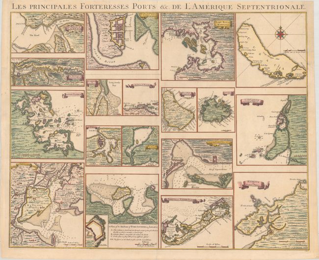
This rare chart shows 18 separate maps of harbors ... (full text available to subscribers)
| Item Detail |
| |
| |
MapMaker: |
Popple/Covens & Mortier
|
|
| |
| |
Subject: |
Colonial Eastern North America & West Indies; North American |
|
| |
Period/Size: |
1740 / 19.0" x 23.9" (48.3 x 60.7 cm)
|
|
| |
Color: |
Colored
|
|
| |
Condition: |
(B+) A crisp impression in contemporary color with a couple archivally repaired wormtracks in unengraved areas at the top corners. The top left and right side borders have been reinstated (4-5" sections) with a small portion of border at top right drawn (condition help) |
|
| |
Source: |
|
|
| |
References: |
Cumming #249. |
|
| |
|
|
| Sales Information |
| |
| |
Price: |
|
|
| |
| |
Offered by: |
Old World Auctions |
|
| |
Catalog: |
Auction No. 181 - Antique Maps, Charts, Atlases & Globes (9527) |
|
| |
Lot/Item #: |
86 |
|
| |
| |
Date: |
02/2021
|
|
| |
| |
|
Antique Maps - Valuation and Pricing, Descriptions, Resources |
|
Home |
Information |
Search |
Register |
Contact Us |
Site Map
Americana Exchange, Inc. © 1999 - 2024 Americana Exchange, Inc.. All rights reserved.
OldMaps.com, the OldMaps.com logo and
AMPR are service marks or registered service marks of Americana Exchange, Inc..
|