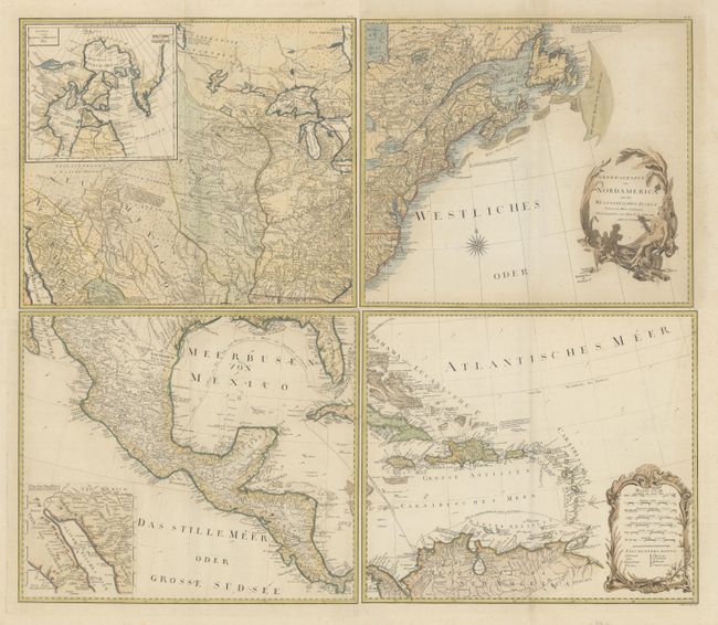
Title:
“Generalkarte von Nordamerica samt den Westindischen Inseln”
Map Maker:
Franz Anton Schrambl
This large-scale map of North America includes exc... (full text available to subscribers)
| Item Detail |
| |
| |
MapMaker: |
Franz Anton Schrambl
|
|
| |
| |
Subject: |
North America |
|
| |
Period/Size: |
1788 / 19.8" x 22.7" (50.3 x 57.7 cm)
|
|
| |
Color: |
Colored
|
|
| |
Condition: |
(B+) Nice impressions on watermarked paper with light scattered foxing that is mostly in the blank margins. There is some faint toning limited to the area around the title cartouche. The first image is a composite image - the map is in 4 separate sheets (condition help) |
|
| |
Source: |
Allgemeiner Grosser Atlas |
|
| |
References: |
McCorkle #788.6; Phillips (A) #694. |
|
| |
|
|
| Sales Information |
| |
| |
Price: |
|
|
| |
| |
Offered by: |
Old World Auctions |
|
| |
Catalog: |
Auction No. 181 - Antique Maps, Charts, Atlases & Globes (9527) |
|
| |
Lot/Item #: |
78 |
|
| |
| |
Date: |
02/2021
|
|
| |
| |
|
Antique Maps - Valuation and Pricing, Descriptions, Resources |
|
Home |
Information |
Search |
Register |
Contact Us |
Site Map
Americana Exchange, Inc. © 1999 - 2024 Americana Exchange, Inc.. All rights reserved.
OldMaps.com, the OldMaps.com logo and
AMPR are service marks or registered service marks of Americana Exchange, Inc..
|