Title:
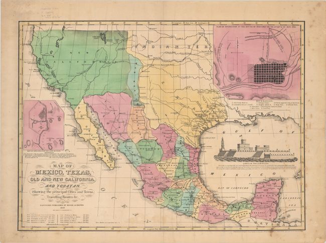
“Map of Mexico, Texas, Old and New California, and Yucatan. Showing the Principal Cities and Towns, Travelling Routes &c.”
Map Maker:
House & Brown
This rare map of the evolving Southwest was lithog... (full text available to subscribers)
| Item Detail |
| |
| |
MapMaker: |
House & Brown
|
|
| |
| |
Subject: |
Southwestern United States & Mexico |
|
| |
Period/Size: |
1847 / 17.3" x 23.6" (44.0 x 60.0 cm)
|
|
| |
Color: |
Colored
|
|
| |
Condition: |
(B+) There is light scattered foxing mostly along the right border and an edge tear at right that extends 3" into the image that has been closed on verso with old paper. A short centerfold separation at bottom and two short edge tears have been closed on (condition help) |
|
| |
Source: |
|
|
| |
References: |
Wheat (TMW) #545; Day #398. |
|
| |
|
|
| Sales Information |
| |
| |
Price: |
|
|
| |
| |
Offered by: |
Old World Auctions |
|
| |
Catalog: |
Auction No. 181 - Antique Maps, Charts, Atlases & Globes (9527) |
|
| |
Lot/Item #: |
308 |
|
| |
| |
Date: |
02/2021
|
|
| |
| |
|
Antique Maps - Valuation and Pricing, Descriptions, Resources |
|
Home |
Information |
Search |
Register |
Contact Us |
Site Map
Americana Exchange, Inc. © 1999 - 2024 Americana Exchange, Inc.. All rights reserved.
OldMaps.com, the OldMaps.com logo and
AMPR are service marks or registered service marks of Americana Exchange, Inc..
|