Title:
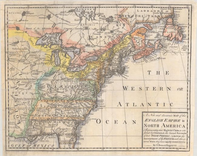
“A New and Accurate Map of the English Empire in North America Representing Their Rightful Claim as Confirm'd by Charters, & the Formal Surrender of Their Indian Friends...”
Map Maker:
Richard Bennett
A very scarce little map issued during the Fren... (full text available to subscribers)
| Item Detail |
| |
| |
MapMaker: |
Richard Bennett
|
|
| |
| |
Subject: |
Colonial Eastern United States & Canada |
|
| |
Period/Size: |
1758 / 9.9" x 12.5" (25.2 x 31.8 cm)
|
|
| |
Color: |
Colored
|
|
| |
Condition: |
(B+) Issued folding on watermarked paper. The sheet has been flattened and professionally backed with tissue to repair a number of edge tears that extend 1-2" into the image at left and right. (condition help) |
|
| |
Source: |
Grand Magazine of Universal Intelligence |
|
| |
References: |
Jolly #GMUI-7. |
|
| |
|
|
| Sales Information |
| |
| |
Price: |
|
|
| |
| |
Offered by: |
Old World Auctions |
|
| |
Catalog: |
Auction No. 181 - Antique Maps, Charts, Atlases & Globes (9527) |
|
| |
Lot/Item #: |
107 |
|
| |
| |
Date: |
02/2021
|
|
| |
| |
|
Antique Maps - Valuation and Pricing, Descriptions, Resources |
|
Home |
Information |
Search |
Register |
Contact Us |
Site Map
Americana Exchange, Inc. © 1999 - 2024 Americana Exchange, Inc.. All rights reserved.
OldMaps.com, the OldMaps.com logo and
AMPR are service marks or registered service marks of Americana Exchange, Inc..
|