Title:
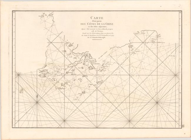
“Carte d'une Partie des Cotes de la Chine et des Isles Adjacentes, Depuis l'Isle Nommee la Pierre Blanche, Jusqu'a Celle de l'Artimon...”
Map Maker:
Jean B.N.D. d'Apres de Mannevillette
This is the French edition of Alexander Dalrymple'... (full text available to subscribers)
| Item Detail |
| |
| |
MapMaker: |
Jean B.N.D. d'Apres de Mannevillette
|
|
| |
| |
Subject: |
Hong Kong, South China Sea |
|
| |
Period/Size: |
1775 / 13.3" x 18.2" (33.8 x 46.3 cm)
|
|
| |
Color: |
Black & White
|
|
| |
Condition: |
(A) A fine impression on a sturdy watermarked sheet with some marginal soiling. (condition help) |
|
| |
Source: |
Le Neptune Oriental |
|
| |
References: |
cf. Howse & Sanderson XLI; Shirley (BL Atlases) M.APR-1c. |
|
| |
|
|
| Sales Information |
| |
| |
Price: |
|
|
| |
| |
Offered by: |
Old World Auctions |
|
| |
Catalog: |
Auction No. 181 - Antique Maps, Charts, Atlases & Globes (9527) |
|
| |
Lot/Item #: |
640 |
|
| |
| |
Date: |
02/2021
|
|
| |
| |
|
Antique Maps - Valuation and Pricing, Descriptions, Resources |
|
Home |
Information |
Search |
Register |
Contact Us |
Site Map
Americana Exchange, Inc. © 1999 - 2024 Americana Exchange, Inc.. All rights reserved.
OldMaps.com, the OldMaps.com logo and
AMPR are service marks or registered service marks of Americana Exchange, Inc..
|