Title:
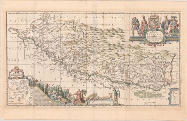
“Vera Totius Marchionatus Badensis, et Hochbergensis, Ceterorumque Ducatuum Landgravionatuum et Comitatuum ad Principes...”
Map Maker:
Jansson/Pitt
This decorative one-and-a-half sheet map centers o... (full text available to subscribers)
| Item Detail |
| |
| |
MapMaker: |
Jansson/Pitt
|
|
| |
| |
Subject: |
Black Forest, Rhine River |
|
| |
Period/Size: |
1681 / 17.6" x 32.2" (44.7 x 81.8 cm)
|
|
| |
Color: |
Colored
|
|
| |
Condition: |
(B+) A sharp impression on watermarked paper with some minor scattered foxing and light toning that is primarily confined to the blank margins. (condition help) |
|
| |
Source: |
The English Atlas |
|
| |
References: |
Van der Krogt (Vol. I) #2630:1.2. |
|
| |
|
|
| Sales Information |
| |
| |
Price: |
|
|
| |
| |
Offered by: |
Old World Auctions |
|
| |
Catalog: |
Auction No. 181 - Antique Maps, Charts, Atlases & Globes (9527) |
|
| |
Lot/Item #: |
493 |
|
| |
| |
Date: |
02/2021
|
|
| |
| |
|
Antique Maps - Valuation and Pricing, Descriptions, Resources |
|
Home |
Information |
Search |
Register |
Contact Us |
Site Map
Americana Exchange, Inc. © 1999 - 2024 Americana Exchange, Inc.. All rights reserved.
OldMaps.com, the OldMaps.com logo and
AMPR are service marks or registered service marks of Americana Exchange, Inc..
|