Title:
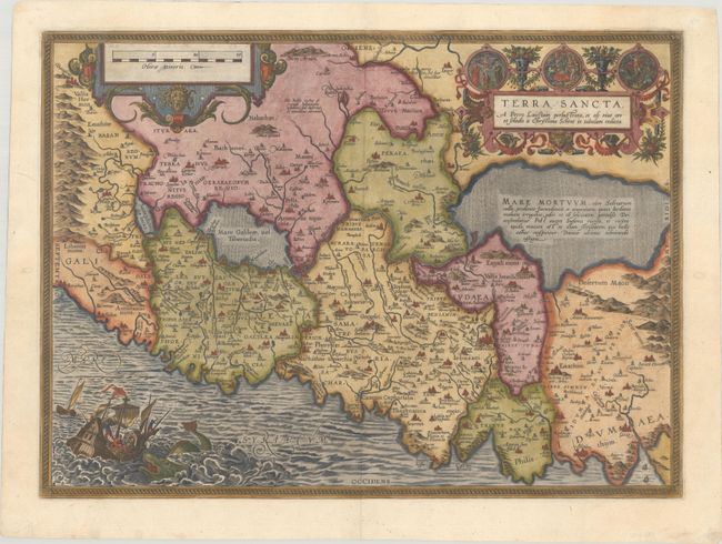
“Terra Sancta, a Petro Laicstain Perlustrata, et ab eius ore et Schedis a Christiano Schrot in Tabulam Redacta”
Map Maker:
Abraham Ortelius
This striking map is considered the most 'modern' ... (full text available to subscribers)
| Item Detail |
| |
| |
MapMaker: |
Abraham Ortelius
|
|
| |
| |
Subject: |
Holy Land |
|
| |
Period/Size: |
1588 / 14.4" x 19.7" (36.6 x 50.1 cm)
|
|
| |
Color: |
Colored
|
|
| |
Condition: |
(A) A sharp impression on a bright sheet with the crossed arrows watermark commonly found on Ortelius maps. There are professional repairs to short centerfold separations at top and bottom and to two worm holes in the blank margins. (condition help) |
|
| |
Source: |
Theatrum Orbis Terrarum |
|
| |
References: |
Laor #543; Nebenzahl (HL) plt. 31; Van den Broecke #173. |
|
| |
|
|
| Sales Information |
| |
| |
Price: |
|
|
| |
| |
Offered by: |
Old World Auctions |
|
| |
Catalog: |
Auction No. 181 - Antique Maps, Charts, Atlases & Globes (9527) |
|
| |
Lot/Item #: |
588 |
|
| |
| |
Date: |
02/2021
|
|
| |
| |
|
Antique Maps - Valuation and Pricing, Descriptions, Resources |
|
Home |
Information |
Search |
Register |
Contact Us |
Site Map
Americana Exchange, Inc. © 1999 - 2024 Americana Exchange, Inc.. All rights reserved.
OldMaps.com, the OldMaps.com logo and
AMPR are service marks or registered service marks of Americana Exchange, Inc..
|