Title:
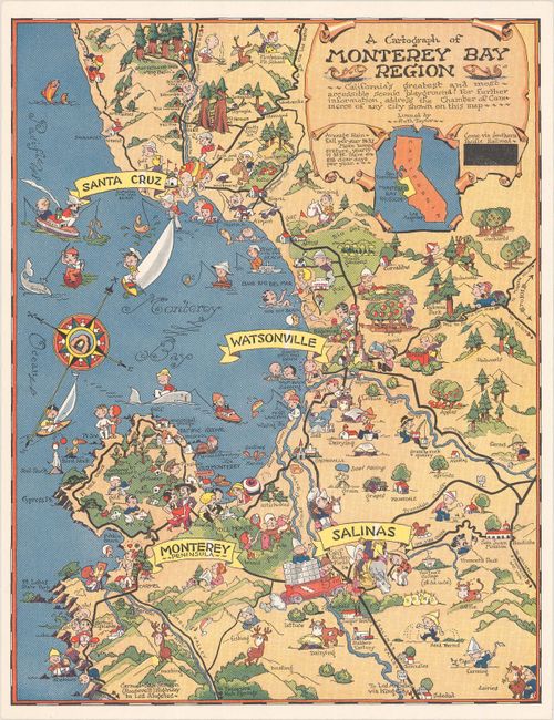
“A Cartograph of Monterey Bay Region - California's Greatest and Most Accessible Scenic Playground!”
Map Maker:
Ruth Taylor White
This is one of White's rarer pictorial maps, and s... (full text available to subscribers)
| Item Detail |
| |
| |
MapMaker: |
Ruth Taylor White
|
|
| |
| |
Subject: |
Monterey Bay, California |
|
| |
Period/Size: |
1933 / 10.4" x 8.1" (26.5 x 20.6 cm)
|
|
| |
Color: |
Colored
|
|
| |
Condition: |
(A+) Clean and bright. (condition help) |
|
| |
Source: |
|
|
| |
References: |
Rumsey #11344. |
|
| |
|
|
| Sales Information |
| |
| |
Price: |
|
|
| |
| |
Offered by: |
Old World Auctions |
|
| |
Catalog: |
Auction No. 182 - Antique Maps, Charts, Atlases & Globes (9528) |
|
| |
Lot/Item #: |
239 |
|
| |
| |
Date: |
04/2021
|
|
| |
| |
|
Antique Maps - Valuation and Pricing, Descriptions, Resources |
|
Home |
Information |
Search |
Register |
Contact Us |
Site Map
Americana Exchange, Inc. © 1999 - 2024 Americana Exchange, Inc.. All rights reserved.
OldMaps.com, the OldMaps.com logo and
AMPR are service marks or registered service marks of Americana Exchange, Inc..
|