Title:
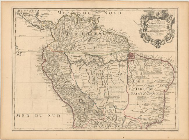
“Carte de la Terre Ferme du Perou, du Bresil et du Pays des Amazones Dressee sur les Descriptions de Herrera de Laet, et des PP. d'Acuna, et M. Rodriguez...”
Map Maker:
Guillaume Delisle
This handsome and important map of the northern pa... (full text available to subscribers)
| Item Detail |
| |
| |
MapMaker: |
Guillaume Delisle
|
|
| |
| |
Subject: |
Northern South America |
|
| |
Period/Size: |
1703 / 19.1" x 25.9" (48.6 x 65.8 cm)
|
|
| |
Color: |
Colored
|
|
| |
Condition: |
(B+) On a sheet with a watermark of a Maltese cross encircled in rosary beads. There is a small stain around the centerfold at top, minor offsetting and tiny wormholes that are only visible when held up to light. (condition help) |
|
| |
Source: |
|
|
| |
References: |
|
|
| |
|
|
| Sales Information |
| |
| |
Price: |
|
|
| |
| |
Offered by: |
Old World Auctions |
|
| |
Catalog: |
Auction No. 182 - Antique Maps, Charts, Atlases & Globes (9528) |
|
| |
Lot/Item #: |
411 |
|
| |
| |
Date: |
04/2021
|
|
| |
| |
|
Antique Maps - Valuation and Pricing, Descriptions, Resources |
|
Home |
Information |
Search |
Register |
Contact Us |
Site Map
Americana Exchange, Inc. © 1999 - 2024 Americana Exchange, Inc.. All rights reserved.
OldMaps.com, the OldMaps.com logo and
AMPR are service marks or registered service marks of Americana Exchange, Inc..
|