Title:
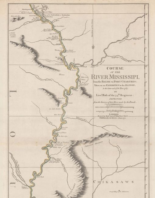
“Course of the River Mississipi, from the Balise to Fort Chartres; Taken on an Expedition to the Illinois, in the Latter End of the Year 1765”
Map Maker:
John Ross
Following its victory over the French in the Seven... (full text available to subscribers)
| Item Detail |
| |
| |
MapMaker: |
John Ross
|
|
| |
| |
Subject: |
Colonial Central United States, Mississippi River |
|
| |
Period/Size: |
1775 / 44.4" x 13.8" (112.8 x 35.1 cm)
|
|
| |
Color: |
Colored
|
|
| |
Condition: |
(A) On watermarked paper with scattered foxing that is almost entirely confined to the blank margins. Issued folding. (condition help) |
|
| |
Source: |
Jefferys' The American Atlas |
|
| |
References: |
Sellers & Van Ee #781; Stevens & Tree #31b. |
|
| |
|
|
| Sales Information |
| |
| |
Price: |
|
|
| |
| |
Offered by: |
Old World Auctions |
|
| |
Catalog: |
Auction No. 182 - Antique Maps, Charts, Atlases & Globes (9528) |
|
| |
Lot/Item #: |
194 |
|
| |
| |
Date: |
04/2021
|
|
| |
| |
|
Antique Maps - Valuation and Pricing, Descriptions, Resources |
|
Home |
Information |
Search |
Register |
Contact Us |
Site Map
Americana Exchange, Inc. © 1999 - 2024 Americana Exchange, Inc.. All rights reserved.
OldMaps.com, the OldMaps.com logo and
AMPR are service marks or registered service marks of Americana Exchange, Inc..
|