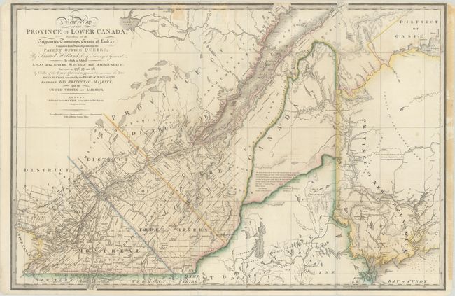
Title:
“A New Map of the Province of Lower Canada, Describing All the Seigneuries, Townships, Grants of Land, &c. Compiled from Plans Deposited in the Patent Office Quebec; by Samuel Holland, Esq. Surveyor General…”
Map Maker:
James Wyld
Title continues: "To Which Is Added a Plan of the ... (full text available to subscribers)
| Item Detail |
| |
| |
MapMaker: |
James Wyld
|
|
| |
| |
Subject: |
Maine & Eastern Canada |
|
| |
Period/Size: |
1838 / 22.7" x 34.2" (57.7 x 86.9 cm)
|
|
| |
Color: |
Colored
|
|
| |
Condition: |
(B) Contemporary color on a sturdy sheet that was issued folding with light offsetting, some small spots, and several fold separations and edge tears that have been closed on verso. There are two tape stains at top and additional tape stains in the right (condition help) |
|
| |
Source: |
A New General Atlas of Modern Geography... |
|
| |
References: |
Tooley (America) p.66-67 #28d. |
|
| |
|
|
| Sales Information |
| |
| |
Price: |
|
|
| |
| |
Offered by: |
Old World Auctions |
|
| |
Catalog: |
Auction No. 182 - Antique Maps, Charts, Atlases & Globes (9528) |
|
| |
Lot/Item #: |
130 |
|
| |
| |
Date: |
04/2021
|
|
| |
| |
|
Antique Maps - Valuation and Pricing, Descriptions, Resources |
|
Home |
Information |
Search |
Register |
Contact Us |
Site Map
Americana Exchange, Inc. © 1999 - 2024 Americana Exchange, Inc.. All rights reserved.
OldMaps.com, the OldMaps.com logo and
AMPR are service marks or registered service marks of Americana Exchange, Inc..
|