Title:
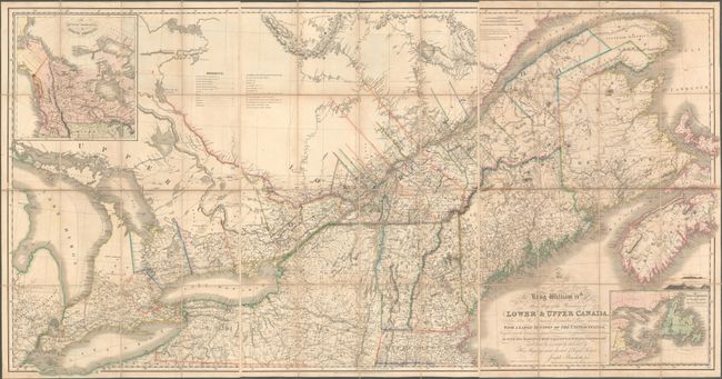
“To His Most Excellent Majesty King William IVth This Map of the Provinces of Lower & Upper Canada, Nova Scotia, New Brunswick, Newfoundland & Prince Edwards Island, with a Large Section of the United States…”
Map Maker:
Joseph Francis Bouchette
This important map of eastern Canada was intended ... (full text available to subscribers)
| Item Detail |
| |
| |
MapMaker: |
Joseph Francis Bouchette
|
|
| |
| |
Subject: |
Northeastern United States & Canada |
|
| |
Period/Size: |
1831 / 37.9" x 24.6" (96.3 x 62.5 cm)
|
|
| |
Color: |
Colored
|
|
| |
Condition: |
(B+) Bold, contemporary outline color with light toning and offsetting. Each sheet has a blindstamp for the Sondley Library in a blank area of the sheet at bottom, and there are stamps on the verso of each sheet from Pack Memorial Public Library, Ashevil (condition help) |
|
| |
Source: |
|
|
| |
References: |
Rumsey #4436. |
|
| |
|
|
| Sales Information |
| |
| |
Price: |
|
|
| |
| |
Offered by: |
Old World Auctions |
|
| |
Catalog: |
Auction No. 182 - Antique Maps, Charts, Atlases & Globes (9528) |
|
| |
Lot/Item #: |
129 |
|
| |
| |
Date: |
04/2021
|
|
| |
| |
|
Antique Maps - Valuation and Pricing, Descriptions, Resources |
|
Home |
Information |
Search |
Register |
Contact Us |
Site Map
Americana Exchange, Inc. © 1999 - 2024 Americana Exchange, Inc.. All rights reserved.
OldMaps.com, the OldMaps.com logo and
AMPR are service marks or registered service marks of Americana Exchange, Inc..
|