Title:
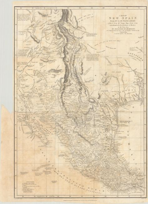
“A Map of New Spain from 16° to 38° North Latitude Reduced from the Large Map Drawn from Astronomical Observations at Mexico in the Year 1804”
Map Maker:
Alexander von Humboldt
This is a reduced version of Humboldt's landmark m... (full text available to subscribers)
| Item Detail |
| |
| |
MapMaker: |
Alexander von Humboldt
|
|
| |
| |
Subject: |
Southwestern United States & Mexico |
|
| |
Period/Size: |
1810 / 16.4" x 11.4" (41.7 x 29.0 cm)
|
|
| |
Color: |
Black & White
|
|
| |
Condition: |
(B) Issued folding with light scattered foxing. There is a short binding tear at left that just enters the border and a 4" separation along the lower left fold that have both been closed on verso with archival tape. (condition help) |
|
| |
Source: |
|
|
| |
References: |
cf. Wheat (TMW) #272; Howes #H-786. |
|
| |
|
|
| Sales Information |
| |
| |
Price: |
|
|
| |
| |
Offered by: |
Old World Auctions |
|
| |
Catalog: |
Auction No. 182 - Antique Maps, Charts, Atlases & Globes (9528) |
|
| |
Lot/Item #: |
361 |
|
| |
| |
Date: |
04/2021
|
|
| |
| |
|
Antique Maps - Valuation and Pricing, Descriptions, Resources |
|
Home |
Information |
Search |
Register |
Contact Us |
Site Map
Americana Exchange, Inc. © 1999 - 2024 Americana Exchange, Inc.. All rights reserved.
OldMaps.com, the OldMaps.com logo and
AMPR are service marks or registered service marks of Americana Exchange, Inc..
|