Title:
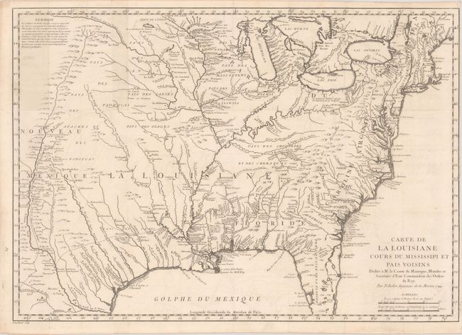
“Carte de la Louisiane Cours du Mississipi et Pais Voisins...”
Map Maker:
Jacques Nicolas Bellin
This interesting map first appeared in the journal... (full text available to subscribers)
| Item Detail |
| |
| |
MapMaker: |
Jacques Nicolas Bellin
|
|
| |
| |
Subject: |
Colonial Eastern United States |
|
| |
Period/Size: |
1744 / 15.6" x 22.1" (39.7 x 56.2 cm)
|
|
| |
Color: |
Black & White
|
|
| |
Condition: |
(B+) Issued folding on a bright sheet with faint offsetting and a couple of short edge tears in the bottom right corner that have been closed on verso with archival tape. Numerous tiny wormholes only visible when held to light have been backed with old p (condition help) |
|
| |
Source: |
Histoire et Description Generale de la Nouvelle France... |
|
| |
References: |
McCorkle #744.1; MCC-96 #703. |
|
| |
|
|
| Sales Information |
| |
| |
Price: |
|
|
| |
| |
Offered by: |
Old World Auctions |
|
| |
Catalog: |
Auction No. 182 - Antique Maps, Charts, Atlases & Globes (9528) |
|
| |
Lot/Item #: |
153 |
|
| |
| |
Date: |
04/2021
|
|
| |
| |
|
Antique Maps - Valuation and Pricing, Descriptions, Resources |
|
Home |
Information |
Search |
Register |
Contact Us |
Site Map
Americana Exchange, Inc. © 1999 - 2024 Americana Exchange, Inc.. All rights reserved.
OldMaps.com, the OldMaps.com logo and
AMPR are service marks or registered service marks of Americana Exchange, Inc..
|