Title:
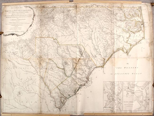
“An Accurate Map of North and South Carolina with Their Indian Frontiers, Shewing in a Distinct Manner All the Mountains, Rivers, Swamps, Marshes, Bays, Creeks, Harbours, Sandbanks and Soundings on the Coasts...”
Map Maker:
Henry Mouzon, Jr.
This rare map is one of the foundation maps of ... (full text available to subscribers)
| Item Detail |
| |
| |
MapMaker: |
Henry Mouzon, Jr.
|
|
| |
| |
Subject: |
Colonial Southeast United States |
|
| |
Period/Size: |
1775 / 39.6" x 55.8" (100.6 x 141.8 cm)
|
|
| |
Color: |
Colored
|
|
| |
Condition: |
(B) Contemporary outline color on sturdy watermarked paper that has been backed with tissue to reinforce and repair several fold separations. Light dampstains are visible along the center joint and top sheet edge, with a small area of loss (approximately (condition help) |
|
| |
Source: |
Jeffery's The American Atlas... |
|
| |
References: |
Cumming (SE) #450; Pritchard & Taliaferro #44; Schwartz & Ehrenberg pp. 186-87; Sellers & Van Ee #1394; cf. Stevens & Tree #11a. |
|
| |
|
|
| Sales Information |
| |
| |
Price: |
|
|
| |
| |
Offered by: |
Old World Auctions |
|
| |
Catalog: |
Auction No. 182 - Antique Maps, Charts, Atlases & Globes (9528) |
|
| |
Lot/Item #: |
177 |
|
| |
| |
Date: |
04/2021
|
|
| |
| |
|
Antique Maps - Valuation and Pricing, Descriptions, Resources |
|
Home |
Information |
Search |
Register |
Contact Us |
Site Map
Americana Exchange, Inc. © 1999 - 2024 Americana Exchange, Inc.. All rights reserved.
OldMaps.com, the OldMaps.com logo and
AMPR are service marks or registered service marks of Americana Exchange, Inc..
|