Title:
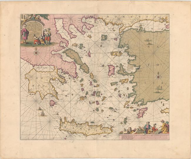
“Paskaerte vande Archipel en de Eylanden daer Omtrent Gelegen, als Candia Serigo en Rodus, Tusschen Golfo de Lepanto Constantinopolen en C. Serdeni in Natolia”
Map Maker:
Johannes van Keulen
This superb sea chart centers on the Aegean Sea, s... (full text available to subscribers)
| Item Detail |
| |
| |
MapMaker: |
Johannes van Keulen
|
|
| |
| |
Subject: |
Eastern Mediterranean |
|
| |
Period/Size: |
1680 / 19.6" x 23.1" (49.8 x 58.7 cm)
|
|
| |
Color: |
Colored
|
|
| |
Condition: |
(A) A nice impression with full contemporary color on a very sturdy sheet with wide margins. There is some light printer's ink residue, a few tiny spots, and remnants of hinge tape on verso. (condition help) |
|
| |
Source: |
|
|
| |
References: |
|
|
| |
|
|
| Sales Information |
| |
| |
Price: |
|
|
| |
| |
Offered by: |
Old World Auctions |
|
| |
Catalog: |
Auction No. 182 - Antique Maps, Charts, Atlases & Globes (9528) |
|
| |
Lot/Item #: |
622 |
|
| |
| |
Date: |
04/2021
|
|
| |
| |
|
Antique Maps - Valuation and Pricing, Descriptions, Resources |
|
Home |
Information |
Search |
Register |
Contact Us |
Site Map
Americana Exchange, Inc. © 1999 - 2024 Americana Exchange, Inc.. All rights reserved.
OldMaps.com, the OldMaps.com logo and
AMPR are service marks or registered service marks of Americana Exchange, Inc..
|