Title:
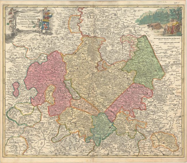
“Landgraviatus Hassiae Inferioris Nova Tabula, in qua Praecipue Ditiones Hasso-Casselenses et Comitatus Waldeck...”
Map Maker:
Johann Baptist Homann
This is a very detailed map of Lower Hessen with i... (full text available to subscribers)
| Item Detail |
| |
| |
MapMaker: |
Johann Baptist Homann
|
|
| |
| |
Subject: |
Central Germany |
|
| |
Period/Size: |
1716 / 19.1" x 22.8" (48.6 x 58.0 cm)
|
|
| |
Color: |
Colored
|
|
| |
Condition: |
(B+) A sharp impression with contemporary color in the map and later color in the cartouches. There is light soiling, two edge tears at top center that have been repaired on verso with old paper, and a 1.5" centerfold separation at bottom that has been c (condition help) |
|
| |
Source: |
|
|
| |
References: |
|
|
| |
|
|
| Sales Information |
| |
| |
Price: |
|
|
| |
| |
Offered by: |
Old World Auctions |
|
| |
Catalog: |
Auction No. 182 - Antique Maps, Charts, Atlases & Globes (9528) |
|
| |
Lot/Item #: |
530 |
|
| |
| |
Date: |
04/2021
|
|
| |
| |
|
Antique Maps - Valuation and Pricing, Descriptions, Resources |
|
Home |
Information |
Search |
Register |
Contact Us |
Site Map
Americana Exchange, Inc. © 1999 - 2024 Americana Exchange, Inc.. All rights reserved.
OldMaps.com, the OldMaps.com logo and
AMPR are service marks or registered service marks of Americana Exchange, Inc..
|