Title:
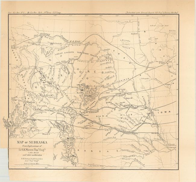
“Map of Nebraska from Explorations of Lt. G.K. Warren, Topl. Engrs. in 1855, 56, & 57, and Other Authorities”
Map Maker:
U.S. War Department
This map of the northwestern Great Plains covers t... (full text available to subscribers)
| Item Detail |
| |
| |
MapMaker: |
U.S. War Department
|
|
| |
| |
Subject: |
Great Plains |
|
| |
Period/Size: |
1858 / 9.1" x 10.3" (23.2 x 26.2 cm)
|
|
| |
Color: |
Black & White
|
|
| |
Condition: |
(B) Issued folding with a small binding trim at bottom left and a 0.5" fold separation also at bottom left that has been closed on verso with archival tape. There is light toning along the folds and some faint offsetting. (condition help) |
|
| |
Source: |
Sen. Ex. Doc. 1, 35th Congress, 2nd Session |
|
| |
References: |
Wheat (TMW) #937. |
|
| |
|
|
| Sales Information |
| |
| |
Price: |
|
|
| |
| |
Offered by: |
Old World Auctions |
|
| |
Catalog: |
Auction No. 182 - Antique Maps, Charts, Atlases & Globes (9528) |
|
| |
Lot/Item #: |
196 |
|
| |
| |
Date: |
04/2021
|
|
| |
| |
|
Antique Maps - Valuation and Pricing, Descriptions, Resources |
|
Home |
Information |
Search |
Register |
Contact Us |
Site Map
Americana Exchange, Inc. © 1999 - 2024 Americana Exchange, Inc.. All rights reserved.
OldMaps.com, the OldMaps.com logo and
AMPR are service marks or registered service marks of Americana Exchange, Inc..
|